

 Slovensko
ROGERS DATA


VFR aeronautical chart - 2022/2023 (VFR-CHART-2022/23)
VFR Rogersdata aeronautical charts, 500k - laminated
- edition 2022: Austira, Czech Republic, Greece, Hungary, Italy, Poland, Portugal, Spain3:
- edition 2022: Croatia&BiH

VFR aeronautical chart Slovenia (VFR-SLOVENIA)
VFR aeronautical chart Slovenia - Slovenija 200k - laminated
Product Description
Special features for this region:
All Rogers Data VFR charts are designed to the following criteria:
- Aeronautical chart on a scale of 1:200.000
- Based on ICAO Annex 4; EU-Commission Regulations; AIP
- Very clear representation of the ATS airspace structure
- Reporting points, border crossing points
- Prohibited, danger- and restricted areas
- Aerial sporting and recreational activities
- Areas with sensitive fauna
- Laminated
Product Description
Special features for this region:
- Approach procedures, traffic pattern, reporting points, holdings
- Recommended VFR Routes
- TRAs temporary reserved airspaces
- Aerial sporting and recreational activities
- Areas with sensitive fauna
- Ultralight landing site
- TAs military training areas (commonly known as MTA in the surrounding countries)
- Significant points (border crossing points)
All Rogers Data VFR charts are designed to the following criteria:
- Aeronautical chart on a scale of 1:200.000
- Based on ICAO Annex 4; EU-Commission Regulations; AIP
- Very clear representation of the ATS airspace structure
- Very detailed highly sophisticated terrain map with shading and relief
- Airports, aerodromes and heliports with additional information
- Radio Navigation Aids with name, frequency and morse code
- TMZ transponder mandatory zones
- Compulsory reporting points, reporting points on request, significant points (border crossing)
- Prohibited, danger- and restricted areas
- Obstacles or group of obstacles
- Minimum Grid Area Altitude
- Isogonic line model with magnetic variation
- With the ROGERS DATA navigation compass 200, track, time and distance in the scale of 1:200.000 can be easily measured

VFR aeronautical chart Croatia & Bosnia and Herzegovina (VFR-CRO-BIH)
VFR aeronautical chart Croatia & Bosnia Herzegovina - Hrvatska & BIH 500k - laminated
Product Description
Special features for this region:
All Rogers Data VFR charts are designed to the following criteria:
- Aeronautical chart on a scale of 1:500.000
- According to ICAO Annex 4; EU-Commission Regulations; AIP
- Clear representation of the ATS airspace structure
- Reporting points, border crossing points
- Prohibited, danger- and restricted areas
- Aerial sporting and recreational activities
- Areas with sensitive fauna
Product Description
Special features for this region:
- Recommended VFR Routes
- Water aerodromes
- Aerial sporting and recreational activities
- Areas with sensitive fauna
- Low level military flight corridors and training areas
- ATZ aerodrome traffic zone
- Significant points (border crossing points)
All Rogers Data VFR charts are designed to the following criteria:
- Aeronautical chart on a scale of 1:500.000
- According to ICAO Annex 4; EU-Commission Regulations; AIP
- Clear representation of the ATS airspace structure
- Detailed highly sophisticated terrain map with shading and relief
- Airports, aerodromes and heliports with additional information
- Radio Navigation Aids with name, frequency and morse code
- TMZ transponder mandatory zones
- Compulsory reporting points, reporting points on request
- Danger- and restricted areas
- Obstacles or group of obstacles
- Minimum Grid Area Altitude
- Isogonic line model with magnetic variation
- With the ROGERS DATA navigation compass 500, track, time and distance in the scale of 1:500.000 can be easily measured

VFR aeronautical chart Austria (VFR-AUSTRIA)
VFR aeronautical chart Austria - Österreich 500k - laminated
Product Description
Special features for this region:
All Rogers Data VFR charts are designed to the following criteria:
- Aeronautical chart on a scale of 1:500.000
- According to ICAO Annex 4; EU-Commission Regulations; AIP
- Clear representation of the ATS airspace structure
- Reporting points, border crossing points
- Danger-and restricted areas
- Aerial sporting and recreational activities
- Areas with sensitive fauna
Product Description
Special features for this region:
- VFR sectors at international airports
- TRAs temporary reserved air spaces
- Aerial sporting and recreational activities
- Areas with sensitive fauna
- Military exercise and training areas
- Significant points (border crossing points)
All Rogers Data VFR charts are designed to the following criteria:
- Aeronautical chart on a scale of 1:500.000
- According to ICAO Annex 4; EU-Commission Regulations; AIP
- Clear representation of the ATS airspace structure
- Detailed highly sophisticated terrain map with shading and relief
- Airports, aerodromes and heliports with additional information
- Radio Navigation Aids with name, frequency and morse code
- TMZ transponder mandatory zones
- Compulsory reporting points, reporting points on request
- Danger- and restricted areas
- Obstacles or group of obstacles
- Minimum Grid Area Altitude
- Isogonic line model with magnetic variation
- With the ROGERS DATA navigation compass 500, track, time and distance in the scale of 1:500.000 can be easily measured

VFR aeronautical chart Hungary (VFR-HUNGARY)
VFR aeronautical chart Hungary - Magyarország 500k - laminated
Product Description
Special features for this region:
All Rogers Data VFR charts are designed to the following criteria:
- Aeronautical chart on a scale of 1:500.000
- According to ICAO Annex 4; EU-Commission Regulations; AIP
- Clear representation of the ATS airspace structure
- Reporting points, border crossing points
- Prohibited, danger- and restricted areas
- Aerial sporting and recreational activities
- Areas with sensitive fauna
Product Description
Special features for this region:
- TRAs temporary reserved air spaces
- Aerial sporting and recreational activities
- Areas with sensitive fauna
- Heliports with name of Operator
- Significant points (border crossing points)
All Rogers Data VFR charts are designed to the following criteria:
- Aeronautical chart on a scale of 1:500.000
- According to ICAO Annex 4; EU-Commission Regulations; AIP
- Clear representation of the ATS airspace structure
- Detailed highly sophisticated terrain map with shading andrelief
- Airports, aerodromes and heliports with additional information
- Radio Navigation Aids with name, frequency and morse code
- TMZ transponder mandatory zones
- Compulsory reporting points, reporting points on request
- Danger- and restricted areas
- Obstacles or group of obstacles
- Minimum Grid Area Altitude
- Isogonic line model with magnetic variation
- With the ROGERS DATA navigation compass 500, track, time and distance in the scale of 1:500.000 can be easily measured

VFR aeronautical chart Italy (VFR-ITALY)
VFR aeronautical chart Italy North - Italia del Nord 500k or
VFR aeronautical chart Italy Center - Italia Centro 500k or
VFR aeronautical chart Italy South & Lampedusa & Malta - Italia Sud & Lampedusa & Malta 500k or
VFR aeronautical chart Italy West Sardegna & Corse - Italia Ovest & Sardegna & Corse 500k
Product Description
Special features for this region:
All Rogers Data VFR charts are designed to the following criteria:
VFR aeronautical chart Italy Center - Italia Centro 500k or
VFR aeronautical chart Italy South & Lampedusa & Malta - Italia Sud & Lampedusa & Malta 500k or
VFR aeronautical chart Italy West Sardegna & Corse - Italia Ovest & Sardegna & Corse 500k
- Aeronautical chart on a scale of 1:500.000
- According to ICAO Annex 4; EU-Commission Regulations; AIP
- Clear representation of the ATS airspace structure
- Reporting points, border crossing points
- Prohibited, danger- and restricted areas
- Aerial sporting and recreational activities
- Areas with sensitive fauna
- laminated
Product Description
Special features for this region:
- Aeroporto, Aviosuperfici and Campo volo
- CTRs and CTRs from a specified lower limit
- Compulsory reporting points, reporting points on request, with ICAO letter code
- Significant points (border crossing)
- Ultra light machine activity ULM/VDS
- Aerial sporting and recreational activities
- Areas with sensitive fauna
- Military exercise and training areas
- Significant points (border crossing points)
All Rogers Data VFR charts are designed to the following criteria:
- Aeronautical chart on a scale of 1:500.000
- According to ICAO Annex 4; EU-Commission Regulations; AIP
- Clear representation of the ATS airspace structure
- Detailed highly sophisticated terrain map with shading and relief
- Airports, aerodromes and heliports with additional information
- Radio Navigation Aids with name, frequency and morse code
- TMZ transponder mandatory zones
- Compulsory reporting points, reporting points on request
- Danger- and restricted areas
- Obstacles or group of obstacles
- Minimum Grid Area Altitude
- Isogonic line model with magnetic variation
- With the ROGERS DATA navigation compass 500, track, time and distance in the scale of 1:500.000 can be easily measured

Leather case for Navigationcompass (RD-CASE)
Leather case for Navigationcompass
- leather case for Rogers Data © Navigationcompass 200, 250 or 500
- handcrafted genuine leather case with lining without Navigationcompass
- leather bag was made especially for Rogers Data © Navigationcompass
- perfect protection of our high-quality Navigationcompass

European Aerodromes South – Panorama Chart (EU-AERODROMES-S)
European Aerodromes South Rogers Data chart – Panorama Chart, Edition 2017-2020
calculating flight times, ranges and radius of action. It shows European aerodromes and contains important topographical information.
Colorful and accurate, these maps clearly depict international boundaries, major cities and towns, rivers, lakes, mountain ranges. Also listed are major airports and aerodromes. This map is great for pilots and aviation enthusiasts alike. This extremely detailed map includes hundreds of airports both civil and military, IFR and VFR. Ideal to get an overview for preliminary flight planning and makes a great wall poster! Urban areas, terrain contours, topographical features including bodies of water and more.
European Aerodromes Rogers Data 2.500k uses a scale of 1:2.500.000.
Whether you're a captain of a jumbo jet, a passenger on their first flight, or anything in between, this map and shown information has something for you! There are 2 map sheets (north and south), in the middle you can stick those ones together. Perfect for School- and Flight preparation-rooms or for your home.
Dimensions: W137,5cm x H94cm
- Panorama map on a scale of 1:2.500.000
- Aerodromes with ICAO code
- Colourful and accurate
- Urban areas
- International borders
- VFR an IFR aerodromes
- Civil- and military aerodromes
calculating flight times, ranges and radius of action. It shows European aerodromes and contains important topographical information.
Colorful and accurate, these maps clearly depict international boundaries, major cities and towns, rivers, lakes, mountain ranges. Also listed are major airports and aerodromes. This map is great for pilots and aviation enthusiasts alike. This extremely detailed map includes hundreds of airports both civil and military, IFR and VFR. Ideal to get an overview for preliminary flight planning and makes a great wall poster! Urban areas, terrain contours, topographical features including bodies of water and more.
European Aerodromes Rogers Data 2.500k uses a scale of 1:2.500.000.
Whether you're a captain of a jumbo jet, a passenger on their first flight, or anything in between, this map and shown information has something for you! There are 2 map sheets (north and south), in the middle you can stick those ones together. Perfect for School- and Flight preparation-rooms or for your home.
Dimensions: W137,5cm x H94cm

European Aerodromes North – Panorama Chart (EU-AERODROMES-N)
European Aerodromes North – Panorama Chart, Edition 2017-2020
calculating flight times, ranges and radius of action. It shows European aerodromes and contains important topographical information.
Colorful and accurate, these maps clearly depict international boundaries, major cities and towns, rivers, lakes, mountain ranges. Also listed are major airports and aerodromes. This map is great for pilots and aviation enthusiasts alike. This extremely detailed map includes hundreds of airports both civil and military, IFR and VFR. Ideal to get an overview for preliminary flight planning and makes a great wall poster! Urban areas, terrain contours, topographical features including bodies of water and more.
European Aerodromes Rogers Data 2.500k uses a scale of 1:2.500.000.
Whether you're a captain of a jumbo jet, a passenger on their first flight, or anything in between, this map and shown information has something for you! There are 2 map sheets (north and south), in the middle you can stick those ones together. Perfect for School- and Flight preparation-rooms or for your home.
Dimensions: W137,5cm x H94cm
- Panorama map on a scale of 1:2.500.000
- Aerodromes with ICAO code
- Colourful and accurate
- Urban areas
- International borders
- VFR an IFR aerodromes
- Civil- and military aerodromes
calculating flight times, ranges and radius of action. It shows European aerodromes and contains important topographical information.
Colorful and accurate, these maps clearly depict international boundaries, major cities and towns, rivers, lakes, mountain ranges. Also listed are major airports and aerodromes. This map is great for pilots and aviation enthusiasts alike. This extremely detailed map includes hundreds of airports both civil and military, IFR and VFR. Ideal to get an overview for preliminary flight planning and makes a great wall poster! Urban areas, terrain contours, topographical features including bodies of water and more.
European Aerodromes Rogers Data 2.500k uses a scale of 1:2.500.000.
Whether you're a captain of a jumbo jet, a passenger on their first flight, or anything in between, this map and shown information has something for you! There are 2 map sheets (north and south), in the middle you can stick those ones together. Perfect for School- and Flight preparation-rooms or for your home.
Dimensions: W137,5cm x H94cm

Slovenia VFR Trip Kit (VFR-TRIP-KIT-SI)
Slovenia Rogers Data VFR Trip Kit 200k
Airspace structure: 2024
Scale: 1:200,000
Format: A5
Airspace structure: 2024
Scale: 1:200,000
Format: A5
- VFR Trip Kit in DIN A5 format with spiral binding
- Compilation of all civil and military airfields in Slovenia
- Approach procedures, traffic patterns and reporting points of all airfields included
- Approach sheets in a scale of 1:200,000
- Airfield maps with aerial photos and graphic additions
- High-quality paper, digitally printed
- Spiral binding in Metal, leaves can be completely folded
- Good handling in the cockpit
- VFR Trip Kit in DIN A5 format with spiral binding
- For the first time, all civil and military airfields in Slovenia are included in a VFR Trip Kit
- Airfield maps with aerial photos and graphic additions
- Approach sheets on a scale of 1:200,000
- Very detailed representation of the airspace
- VFR sectors Airports, VFR sectors at airfields
- Arrival and departure procedures, traffic patterns, reporting points, waiting procedures
- Detailed special topographic background map with hillshading and relief
- The VFR Trip Kit was produced on very high-quality, stable paper of excellent quality
- Sheets can be completely turned over, good handling in the cockpit
- Index of airfields with the respective frequency
- Interception signals, conversion table, Morse code, ATC Light Gun Signals
- Altitude Correction, Military Aircraft National Insignia, ALPFOR key Slovenia
- BCMT and ECET table
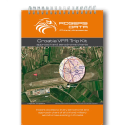
Croatia VFR Trip Kit (VFR-TRIP-KIT-CRO)
Croatia Rogers Data VFR Trip Kit 200k
Airspace structure: 2024
Scale: 1:200,000
Format: A5
Airspace structure: 2024
Scale: 1:200,000
Format: A5
- VFR Trip Kit in DIN A5 format with spiral binding
- Compilation of all civil and military airfields (including water aerodromes) Croatia
- Approach procedures, traffic patterns and reporting points of all airfields included
- Approach sheets in a scale of 1:200,000
- Airfield maps with aerial photos and graphical additions
- High-quality paper, digital printed
- Spiral binding in metal, sheets can be completely turned over
- Easy to handle in the cockpit
- VFR Trip Kit in DIN A5 format with spiral binding
- For the first time, all of Croatia's civil and military airfields are included in a VFR Trip Kit
- Airfield maps with aerial photos and graphic additions
- Approach sheets on a scale of 1:200,000
- Very detailed representation of the airspace
- VFR sectors Airports, VFR sectors at airfields
- Arrival and departure procedures, traffic patterns, reporting points, waiting procedures
- Detailed special topographic background map with hillshading and relief
- The VFR Trip Kit was produced on very high-quality, stable paper of excellent quality
- Sheets can be completely turned over, good handling in the cockpit
- Index of airfields with the respective frequency
- Interception signals, conversion table, Morse code, ATC Light Gun Signals
- Altitude Correction, Military Aircraft National Insignia
- BCMT and ECET table
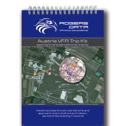
Austria VFR Trip Kit (VFR-TRIP-KIT-AT)
Austria Rogers Data VFR Trip Kit 200k
Airspace structure: 2024
Scale: 1:200,000
Format: A5
Airspace structure: 2024
Scale: 1:200,000
Format: A5
- VFR Trip Kit in DIN A5 format with spiral binding
- Compilation of all civil and military airfields in Austria
- Approach procedures, traffic patterns and reporting points of all airfields included
- Approach sheets in a scale of 1:200,000
- Airfield maps with aerial photos and graphic additions
- High-quality paper, digitally printed
- Spiral binding in Metal, leaves can be completely folded
- Good handling in the cockpit
- VFR Trip Kit in DIN A5 format with spiral binding
- For the first time, all of Austria's civil and military airfields are included in a VFR Trip Kit
- Airfield maps with aerial photos and graphic additions
- Approach sheets on a scale of 1:200,000
- Very detailed representation of the airspace
- VFR sectors Airports, VFR sectors at airfields
- Arrival and departure procedures, traffic patterns, reporting points, waiting procedures
- Detailed special topographic background map with hillshading and relief
- The VFR Trip Kit was produced on very high-quality, stable paper of excellent quality
- Sheets can be completely turned over, good handling in the cockpit
- Index of airfields with the respective frequency
- Interception signals, conversion table, Morse code, ATC Light Gun Signals
- Altitude Correction, Military Aircraft National Insignia, ALPFOR key Austria
- BCMT and ECET table
- 1