

 Slovensko
 Latest Products
-
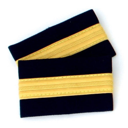
 One bar Pilot Epaulettes (I)
12,00€ Inc Tax
One bar Pilot Epaulettes (I)
12,00€ Inc Tax -
 One bar Pilot Epaulettes (I)
12,00€ Inc Tax
One bar Pilot Epaulettes (I)
12,00€ Inc Tax -
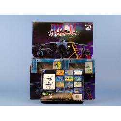 Modern Jet Fighter kit
18,00€ Inc Tax
Modern Jet Fighter kit
18,00€ Inc Tax -
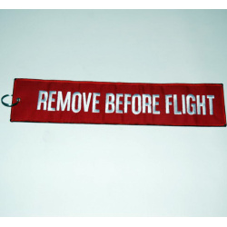 Remove Before Flight Keychain - 17x4.5cm
8,00€ Inc Tax
Remove Before Flight Keychain - 17x4.5cm
8,00€ Inc Tax -
Remove Before Flight Keychain - 36x8cm
17,90€ Inc Tax
-
 Magnet Boeing 737
14,00€ Inc Tax
Magnet Boeing 737
14,00€ Inc Tax -
 Leather Pilot Jacket A2, brown
245,00€ Inc Tax
Leather Pilot Jacket A2, brown
245,00€ Inc Tax -
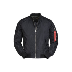 US MA1® Flight Jacket, black (summer )
49,00€ Inc Tax
US MA1® Flight Jacket, black (summer )
49,00€ Inc Tax


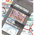
VFR aeronautical chart Croatia & Bosnia and Herzegovina
29,90€ Inc Tax
VFR aeronautical chart Croatia & Bosnia Herzegovina - Hrvatska & BIH 500k - laminated
Product Description
Special features for this region:
All Rogers Data VFR charts are designed to the following criteria:
- Aeronautical chart on a scale of 1:500.000
- According to ICAO Annex 4; EU-Commission Regulations; AIP
- Clear representation of the ATS airspace structure
- Reporting points, border crossing points
- Prohibited, danger- and restricted areas
- Aerial sporting and recreational activities
- Areas with sensitive fauna
Product Description
Special features for this region:
- Recommended VFR Routes
- Water aerodromes
- Aerial sporting and recreational activities
- Areas with sensitive fauna
- Low level military flight corridors and training areas
- ATZ aerodrome traffic zone
- Significant points (border crossing points)
All Rogers Data VFR charts are designed to the following criteria:
- Aeronautical chart on a scale of 1:500.000
- According to ICAO Annex 4; EU-Commission Regulations; AIP
- Clear representation of the ATS airspace structure
- Detailed highly sophisticated terrain map with shading and relief
- Airports, aerodromes and heliports with additional information
- Radio Navigation Aids with name, frequency and morse code
- TMZ transponder mandatory zones
- Compulsory reporting points, reporting points on request
- Danger- and restricted areas
- Obstacles or group of obstacles
- Minimum Grid Area Altitude
- Isogonic line model with magnetic variation
- With the ROGERS DATA navigation compass 500, track, time and distance in the scale of 1:500.000 can be easily measured
- Availability: 3-7 Days
- Model: VFR-CRO-BIH
-
Manufacturer:


-
 VFR aeronautical chart Germany
34,90€ Inc Tax
VFR aeronautical chart Germany
34,90€ Inc Tax -
 VFR aeronautical chart Italy
29,90€ Inc Tax
VFR aeronautical chart Italy
29,90€ Inc Tax -
 VFR aeronautical chart Hungary
29,90€ Inc Tax
VFR aeronautical chart Hungary
29,90€ Inc Tax -
 VFR aeronautical chart Austria
24,90€ Inc Tax
VFR aeronautical chart Austria
24,90€ Inc Tax -
 VFR aeronautical chart Slovenia
29,90€ Inc Tax
VFR aeronautical chart Slovenia
29,90€ Inc Tax -
 Chart Organizer
25,00€ Inc Tax
Chart Organizer
25,00€ Inc Tax -
 Removable Pens for Charts
16,10€ Inc Tax
Removable Pens for Charts
16,10€ Inc Tax -
 Staedtler Lumocolor F 318/4
8,60€ Inc Tax
Staedtler Lumocolor F 318/4
8,60€ Inc Tax -
 ASA Yoke Clip
21,00€ Inc Tax
ASA Yoke Clip
21,00€ Inc Tax -
 European Aerodromes South – Panorama Chart
28,70€ Inc Tax
European Aerodromes South – Panorama Chart
28,70€ Inc Tax


